
The militarily ascendant status of India and the rearmament efforts of Pakistan and China resulted in a shift in the country’s military doctrine. India’s nuclear doctrine was modified in response to the modernisation and expansion of the PRC’s nuclear missile capability. An important long-term objective for India is to offset the strategic threat posed by China in the region by generating a compelling potential for dependable military “deterrence” (rather than “persuasion,” as previously) against the Chinese use of nuclear missile systems.
Thus, the change from defence neutrality to parity doctrine has been finalised, influencing India’s space policy. The Indian government debated the economic and scientific nature of the space programme until March 2019. Midway through the 2000s, a pattern of militarisation of space policy emerged. Previously, it was intended to collect meteorological and cartographic data, facilitate communication and economic growth, and implement manned flights and deep space exploration. A turning point occurred in 2019: for the first time, the outlines of a comprehensive military space policy were institutionalised.
Let us examine the major contours of the development of the military components of India’s space program and the potential for its growth in terms of organisation and technical equipment. Despite efforts to qualitatively intensify activity in this field, politics is hampered by the imperfection of institutions and technical backwardness.
Reasons for changing the space policy
Challenges in the military field have impacted India’s space policy. Among these challenges are the following:
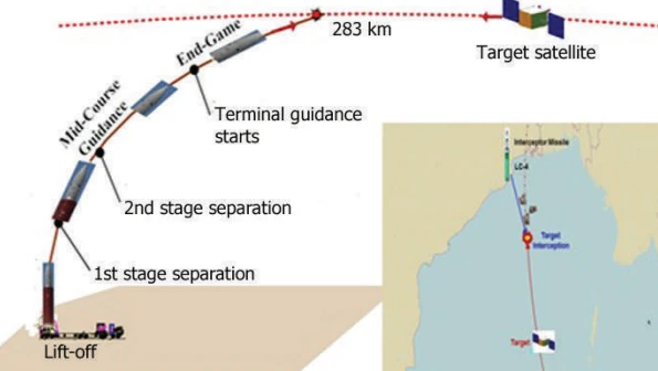
- China’s successful anti-satellite test, a display of spacecraft-destroying missile capability, spurred India to increase its efforts in this sector. Therefore, India conducted anti-satellite weapon tests in 2012 – Mission Shakti. This weapon requires a reliable radio intelligence service and missile attack warning systems for effective usage.
- Strengthening China’s military capabilities: Establishing bases in Djibouti, Pakistan, Sri Lanka, Bangladesh, and Myanmar demonstrates the PRC’s strategic commitment to its presence in the Indian Ocean. The Chinese Navy, armed in the future with advanced anti-ship missiles and sea-launched cruise missiles (with a range of up to 3,000 kilometres), poses a threat of striking Indian territory without entering the line of sight of surveillance systems. Modernising India’s Navy, which involves rearmament, is one of the choices for confronting challenges to the country’s national security ( including special nuclear munitions). The Brahmos anti-ship cruise missile (Brahmos) and the recently developed Nirbhay missile (Nirbhay), which need navigation, surveillance, and target designation, are among the sorts of weaponry garnering more attention.
- During the Kargil battle of 1999, inadequate provisioning of the Indian armed forces with survey and navigation equipment. This fight exposed the difficulties encountered by the Indian military in delivering technical intelligence, cartography, and navigational data. A commission was established to investigate India’s intelligence failures during the conflict. During its research, it was determined that the technical types of surveillance, specifically optical-electronic and radar surveys, must be improved. Having encountered issues with GPS data during the fight, India has been developing its satellite navigation system, presently known as NavIC, since 2006.
- The expansion of Pakistan’s military capacity: The Pakistani Navy’s strategy includes impeding the movement of tankers from the Arabian Peninsula. To implement the strategy, the fleet is being augmented by Khalid-class submarines, ” Type 41 Yuan ” submarines manufactured in China, and F-22P-type frigates manufactured in China.
The issues mentioned above necessitate that India adopts new approaches to its military space policy, including
- altering the role of space directly in both organisational and budgetary terms;
- strengthening the role of the Navy, which requires a qualitative and quantitative change in the means of space support for the fleet (navigation, telecommunications, and Earth remote sensing spacecraft);
- and ensuring the need for missile attack warning systems.
Organisational changes
Before 2019, India’s space policy was administered by the Department of Space, which comprised the Indian Space Research Organization (ISRO). It was involved in military projects till 2019. Currently, ISRO is responsible for the design, production, and operation of spacecraft, launch vehicles, and space infrastructure. This organisation is primarily responsible for the civil space exploration programme and occasionally military surveillance satellites.
The Defence Research and Activities Organization (DRDO) is an additional space policy executor. The organisation’s current objectives include coordinating and developing new weaponry and military equipment types, such as micro- and nanosatellites and a communication system based on the GSAT-6 communication satellite.
The design of the first military satellite, CCI-Sat, by a subsidiary laboratory of the Defence Electronics Research Laboratory (DRLR) is evidence of work in the domain.
In 2005, the Ministry of Defence decided to create a military technical reconnaissance system (Military Surveillance and Reconnaissance System) consisting of a two-component reconnaissance system (all-weather and round-the-clock radar and optoelectronic reconnaissance in the Indian Ocean zone), NCU, and NCPOR target information, and radar and optoelectronic spacecraft were also planned.
The Indian Space Commission was re-established in February 2015 with ten specialists. It is comprised of three scientific community representatives, the chairman of ISRO, a representative of the Ministry of Finance, two government representatives, the chief secretary to the prime minister, the secretary to the foreign minister, and the national security adviser. The Commission is required to submit a space development programme to the Prime Minister. Consequently, the Indian business is entering a new space market.
The use of the space constellation is coordinated by the Integrated Defence Cell established in 2008 in the Integrated Defence Staff (IDS). The agency must order and oversee a space constellation comparable to those in Russia, China and the United States. According to the logic of evolution, the next phase in the growth of the military space programme should be the establishment of a distinct space command, as confirmed by the statements of the former Chief of the Indian Air Force, Shashi Tyagi. This subject has been discussed at all levels of government in India over the past decade, which is pretty usual.
In May 2019, it was decided to establish the Defence Space Agency (DSA), which will organise military activity in space. Also, in June 2019, an IndSpaceEx tabletop exercise was held, whose anti-Chinese stance was evident from its containment language.
The DSA and its research arm will test anti-satellite weapons based on new physical principles, such as space inspectors and laser weapons.
According to the Indian government, a change in licencing policy and a new head of DRDO is required to overcome the challenges in the field of radio electronics, which stem from the inability of the local sector to develop current military equipment.
As a result of the 1992 reforms, the licensing of the development and production of electronic radio equipment was retained. But, starting in July 2014, the government has allowed the license-free production of the following products: Computing systems, avionics, software, combat control systems, engineering and design services, cables, intelligence equipment, simulator training services, body armour and vehicle armour, weather radars, and information display systems—these categories of military equipment require government permission. At the same time, a license is required to produce spacecraft. India aims to attract foreign partners to the production on its territory of those types of military products that have been liberalised in full accordance with the government’s policy of import substitution.
The primary goals and objectives of the design of future space vehicles
The development of the Indian space system goes in two directions: 1) increase and modernisation of the space constellation of military and dual-use vehicles; 2) development of the ground network.
The satellite surveillance challenge
The production of spacecraft for Earth remote sensing, communications, and navigation is the most crucial aspect of developing a space constellation. Also important is developing satellites for radio-technical reconnaissance and a missile attack warning system. Developing the ground complex requires constructing control systems, telemetry, and targeted information transfer.
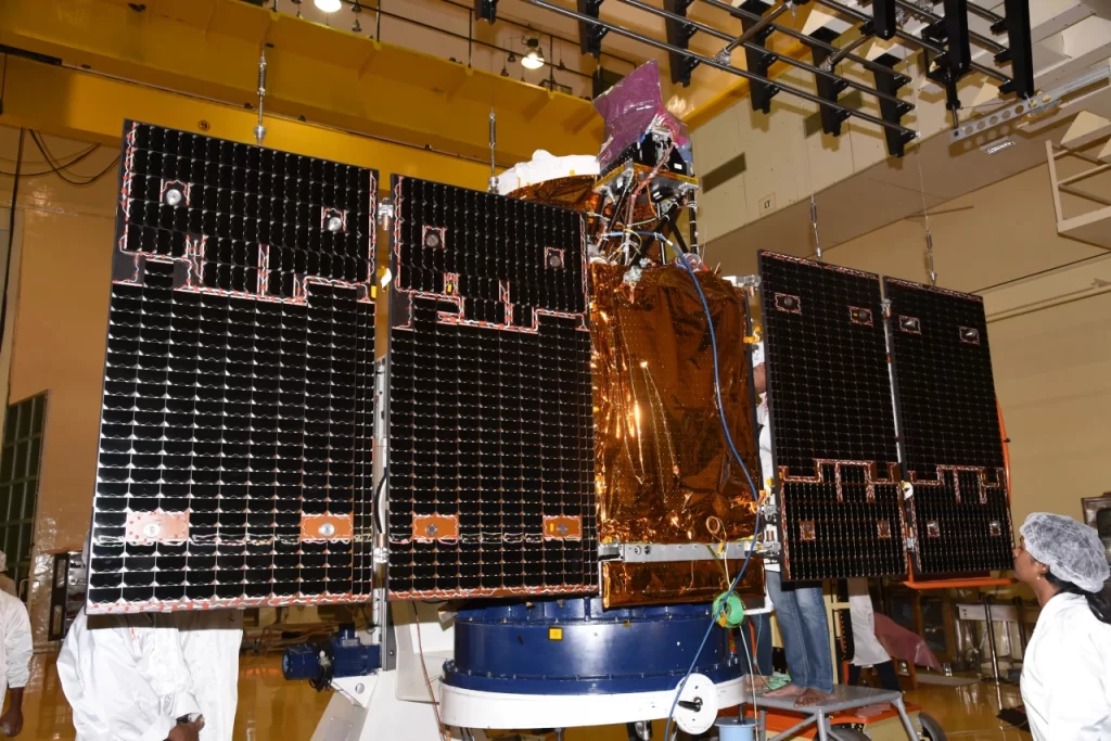
Cartographic instruments of the Cartosat system, which have a spatial resolution in the panchromatic mode of approximately 0.8 metres and a swath of 9.6 kilometres, represent the optical range of remote sensing devices for the Earth. According to unsubstantiated reports, the Indian Ministry of Defence commissioned the development of these gadgets. Therefore, they are dual-function devices.
In addition, the Cartosat-3 series was introduced in 2018 as a cartography device with a resolution of 0.25 metres in panchromatic mode, 1 metre in multispectral mode, and 5 metres in infrared mode. The capture bandwidth in panchromatic mode is 4 kilometres. Thus, it is possible to argue that the qualities of the identified spacecraft are military. Its civilian application (cartography) is illogical.
Utilising AWACS aircraft is a component of creating long-range radar and electronic intelligence in India (long-range radar detection and control). Space radar and radio engineering systems assume a unique function concerning the limits imposed on aviation systems.
India built and launched the RISAT-2 spacecraft in 2008 as part of its development of space radar reconnaissance satellites. The RISAT-2 satellite, which was developed in collaboration with Israel, has a scanning resolution of no more than 50 centimetres and the capacity to lock on a moving target. The satellite was created in collaboration with a foreign state, demonstrating difficulties in developing radio-electronic systems. According to Indian media, it will be used “to monitor borders around the clock and assist the government in anti-terrorist and counter-sabotage operations.” Therefore, the satellite serves a military function.
The development of the first spacecraft, the communication-focused reconnaissance vehicle CCI-SAT (Communication-Centric Intelligence Satellite), is particularly important. The satellite will have a synthetic aperture radar, indicating its primary radar function. The Director of the Defence Research and Development Laboratory (DRDL) is building the intended equipment, G. Bhupati, confirms this: “It will be superior to RISAT-2.” The satellite’s potential to conduct electronic intelligence is also of interest; this notion is bolstered by reports that the satellite will be included in India’s anti-satellite weapons system. This information shows that these satellites’ purposes are radar, electronic, and electronic intelligence. According to the 2010 plans, the satellite was intended to be launched in 2014. Due to the absence of information on this satellite in public sources (the NORAD catalogue), it can be assumed that its development was fraught with obstacles similar to those described above.
Microsat-R, which was launched in January 2019 as the first military spacecraft, became the target for testing anti-satellite weaponry.
Regarding navigational spacecraft, India has developed its own IRNSS constellation covering the Indian Ocean and Indian territory. This system is complete and meets the accuracy requirements outlined in terms of reference (up to 2 m).
Creating a satellite for a missile attack warning system is of great importance. India is currently unable to produce this type of satellite, although efforts are being made to do so. To work with the space constellation, the permanent Antarctic station “Bharati” constructed a control and measuring station in 2012. Space communications are used to maintain contact with the station.
The launcher challenge
India has to create a vehicle capable of launching satellites into Low Earth Orbit (LEO) at will, which ISRO has been reluctant to do as it has a mandate for peaceful use of space.
The DRDO has initiated the development of Veda, a 150-ton Vehicle for Defence Application Mobile that will be utilised to launch defence satellites. The road-transportable VEDA could lessen India’s dependence on ISRO. VEDA may be launched rapidly using improvised launch pads, eliminating the need for a specialised launch pad.
DRDO Veda is a DSA project. Project Veda is managed by DRDL, which also develops the Agni missile family.
The ground space network
The Indian ground-based space network enables an efficiency of around 30 minutes between assigning a task for the spacecraft’s intended usage and transmitting target information to Earth. In addition, a monitoring and measuring station was constructed in Vietnam under the auspices of scientific and technical cooperation to expand the longitude monitoring capabilities. Thus, India can more effectively dominate the Indian and Pacific Oceans.
The challenges on the horizon
The Indian military-technical community has the problem of overcoming the obstacles in precision radars and cutting-edge electronic equipment. India can develop contemporary space communications, remote sensing, and navigational systems. However, these systems are inferior to American equivalents and more comparable to Chinese ones.
Despite the declared peaceful character of the Indian space programme, it is growing increasingly militarised.
The Indian military space programme is at a key juncture in its evolution when it is necessary to develop several significant initiatives, such as fleet support, and respond to emerging space-related issues.