
When it was first conceived, EMIT’s primary objective was to map ten critical minerals found in arid regions of the Earth and impact climate through dust that is carried by the wind.
The EMIT sensor, which is now orbiting the Earth onboard the International Space Station, exposes worldwide methane emissions that have previously been unknown.
Using the information that EMIT obtains, scientists and policymakers can address the Earth’s Surface Mineral Dust Source Investigation, one of the most powerful greenhouse gases contributing to global warming.
The presence of greenhouse gases in the atmosphere of the Earth is analogous to a natural blanket. Our planet is kept at a suitable temperature for life because it can retain part of the sun’s energy. However, it is possible for an excessive amount of greenhouse gases, such as methane, to result in an overheating effect, which can lead to issues such as climate change.
As mentioned, EMIT was initially designed to provide a cartographic representation of ten key minerals located in arid regions of the Earth and whose dust emissions are responsible for regulating the atmosphere. The capability of the sensor to detect methane was an unanticipated bonus, even though it was not among its major purposes. Since August 2022, the EMIT has been compiling a database that contains more than 750 different sources of methane emissions. These sources encompass many features, such as their size, permanence, urban location, and the regularity with which they come into action. A new study that demonstrates how the effectiveness of EMIT has greatly surpassed the expectations of its developers has been published in the journal Science Advances.
Methane traps atmospheric heat considerably more effectively than carbon dioxide, the most prevalent greenhouse gas. In contrast to carbon dioxide, which persists for hundreds of years, methane tends to warm the planet by a factor of approximately ten over ten years. Various human activities, including agriculture, waste disposal, gas and hydrocarbon extraction, and industrial processes produce methane. By identifying methane sources, EMIT can assist those in control of these activities in reducing emissions to combat climate change and reduce their environmental impact.
The capability of EMIT to identify sources emitting methane in quantities ranging from tens of thousands to hundreds of pounds per hour stunned all observers. This is significant because it enables the detection of more “super-emitters,” or sources that emit significantly more methane than others.
For the new study, a comparative examination of the data received from EMIT and airborne sensors that detect methane by flying over specific locations is carried out. The study found that EMIT can capture between sixty and eighty-five per cent of the methane emissions that are generally visible to devices carried by air.
Airborne instruments are more expensive and have fewer capabilities than EMIT, even though they are considered more sensitive. They must know that methane is present in the area; nevertheless, they can’t cover every region of the world, particularly those that are too remote, dangerous, or expensive. In addition, they only continue to collect data for short periods.
On the other hand, EMIT is situated around 250 kilometres (400 miles) from the space station, which affords it a broader vision of the globe compared to the space station. EMIT conducts surveys in arid locations that are most likely to produce dust and methane. It does this by moving from south to north latitude by 51.6 degrees. It is the instrument responsible for acquiring “scenes,” which are photographs of the surface measured in dimensions of 50 miles by 50 miles (80 kilometres by 80 kilometres). With the help of EMIT, it is possible to observe many places that aerial devices have never approached.
According to Robert O. Green, the main investigator of EMIT and a senior research scientist at JPL, the amount and magnitude of methane plumes that EMIT has quantified in the vicinity of our planet are remarkable.
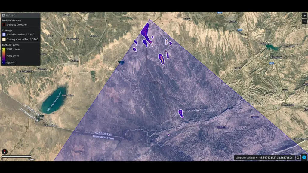
The EMIT scientific team produces methane dispersion maps to ascertain the source locations of methane emissions. A website accessible to the general public provides access to these maps. Additionally, the data can be found at the Land Processes Distributed Active Archive Centre (LP DAAC), established by the United States Geological Survey and NASA as a joint repository of Earth science information.
Since the commencement of data accumulation in August 2022, EMIT has acquired more than 50,000 scenarios. The instrument identified a cluster of emission sources in southern Uzbekistan that had received scant attention before September 1, 2022. Twelve methane columns were observed at EMIT, each releasing around 22,559 kilograms (49,734 pounds) of methane per hour.