
Marut Drones, one of India’s major drone manufacturers, delivered drones to the National Mineral Development Corporation (NMDC) to pioneer “Drone-Based Mineral Exploration” in India. NMDC purchased two bespoke Octacopter drones from Marut Drones. This collaboration represents a significant advancement in mineral exploration by integrating modern technology to improve precision and mapping for sustainable mining methods.
Marut has reached a historic milestone by developing India’s first set of customised drones, states the company release. These drones represent a first for the country and introduce modern sensors used for the first time in India, primarily for mineral prospecting. The Mineral Exploration Drone by Marut Drones offers cutting-edge technologies, including advanced sensors like magnetometers, hyperspectral cameras, and lidar, which improve its exploration and mapping capabilities. Its revolutionary coaxial design ensures stability and accurate manoeuvrability, critical for successful mineral exploration.
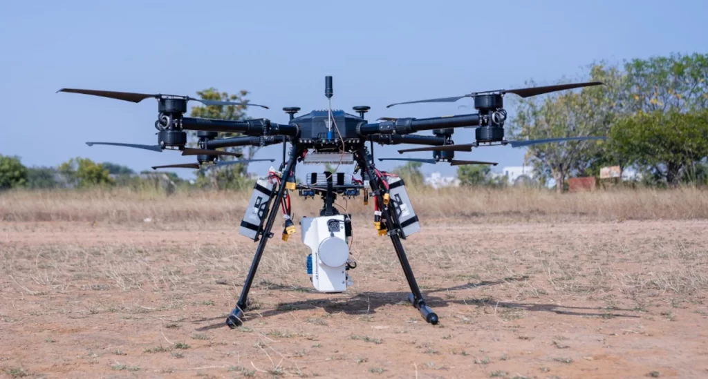
Prem Kumar Vislawath, CEO of Marut Drones, said it’s an Octaquad Coaxial X8 drone that the company created specifically for NMDC. Every component of this drone, including the motors and propeller systems, was built in India. The organisation has been producing tailored drones for various sectors in the country through research and development conducted in cutting-edge infrastructure. He stated that introducing drone-based mineral exploration seeks to transform exploration methods, particularly in the search for vital minerals such as lithium, copper, gold, diamond, rare earth elements, and other essential minerals.
This is NMDC’s first drone-based hyperspectral magnetic investigation, and Marut Drones manufactures and calibrates the drones. Mission planning determines the fly spacing and height, followed by a hyperspectral survey to ensure that the acquired land overlaps by 30% during the drone flight. The data is then analysed by NMDC using Hyperspec III and ENVI software. Similarly, in drone-based magnetic surveying, the drones are calibrated, and the spacing and height are determined before the flight. The Geometrics Magarrow Magnetometer collects magnetic data, and NMDC processes the data using Geometrics and Geosoft Oasis Montage software.
The survey landscape, hitherto hampered by heavy equipment and difficult terrains, is changing. The drones make the magnetic survey five times faster and ten times cheaper. This emerging technology enables drones to fly closer to the surface, improving data collecting with higher resolution and making surveys more efficient and cost-effective.


